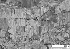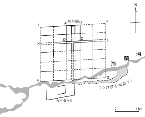


Plan of Zhongjing Xiandefu restored by Noboru Ogata using the above satellite
photograph
Zhongjing Xiandefu (Central Capital), one of the five capitals of the Bohai State, was king’s capital for a short time circa 750. The ruin of Xigucheng near Helong, Jilin Province in northeastern China have been considered the site of Zhongjing. It is located in the basin in which Hailan River flows from west to east.
Kojima (1997), using Masaru Saitô’s collection of aerial photographs, suggested the existence of an outer city with grid-pattern streets around Xigucheng. In his theory, Xigucheng was the inner city of Zhongjing. I reexamined his theory using CORONA Satellite photographs taken on October 9, 1964 and April 7, 1967. Patterns of fields and snow marks show the remains of the main street and the lateral street along the southern side of Xigucheng. Patterns of the canals also suggest traces of the outer city wall. From these traces, I presented my reconstruction of the whole city of Zhongjing. I also hypothesized that when the city plan of Zhongjing was implemented, the channel of Hailan River was changed.
By Noboru Ogata, Emeritus, Kyoto University