Cartesian Addressing System in the Ancient City
 In 1979, a bronze plate of an epitaph
was discovered from an old tomb on a hill in the eastern suburbs
of Nara City. From the words on the plate, it became clear that
the buried person was Ô-no-Yasumaro, a man from the 7th
to the 8th century. This was big news because he was famous for
compiling Japan's first history, Kojiki. The epitaph states
the following.
In 1979, a bronze plate of an epitaph
was discovered from an old tomb on a hill in the eastern suburbs
of Nara City. From the words on the plate, it became clear that
the buried person was Ô-no-Yasumaro, a man from the 7th
to the 8th century. This was big news because he was famous for
compiling Japan's first history, Kojiki. The epitaph states
the following.
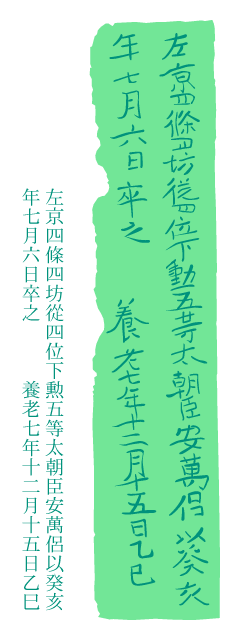
Ô-no-Ason-Yasumaro, a resident (in the city-block) of
the fourth Jô (row) and fourth Bô (column) in the
Left City (of the Capital), at the junior fourth-rank lower in
the Court and the fifth Order of Merit, died on the 6th day,
7th month of the year of Gui-Hai [the 60th year of the Chinese
zodiac cycle] (August 11, 723 AD by the Julian calendar).
(Inscribed) on the 15th day, 12th month, 7th year of the Yôrô
era (January 15, 724 AD by the Julian calendar).
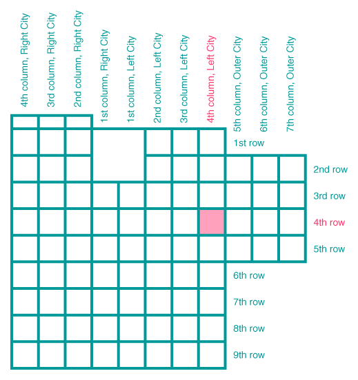
This description informs us that, in the ancient capital of
Nara, each city-block was specified by row and column numbers
in a way somewhat similar to the Cartesian coordinate system.
In China's capital Chang-an, after which Japan modeled its capital,
such an addressing system seems not to have been adopted. Instead,
the Chinese named each city-block in the capital.
The epitaph of Ô-no-Yasumaro.
The following illustration shows how a city-block was specified
in ancient Nara.
By Noboru Ogata, Emeritus, Kyoto University

Back to the Index of Soramitsu