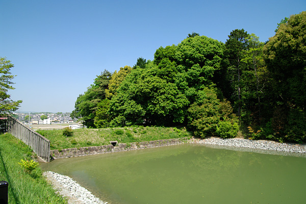
The ground view of Gosashi Kofun, known as Empress Jingū’s tomb (bottom left).
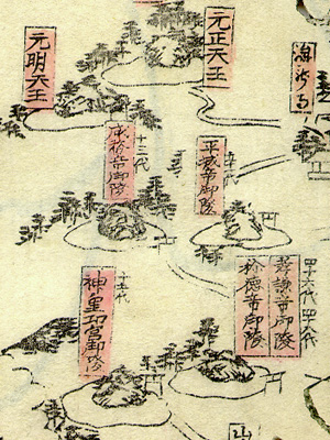
The corresponding part from a woodblock-printed map of the 19th century (bottom right).
|
|
|
|
|
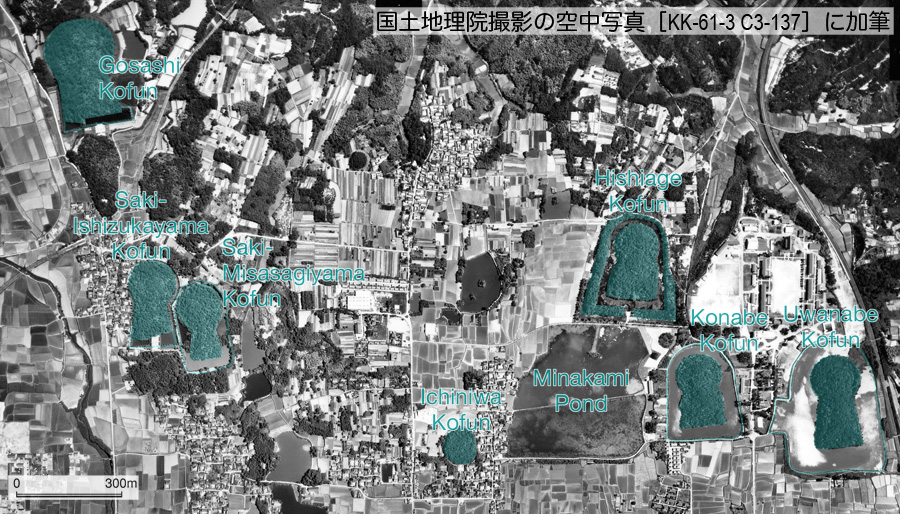
| An aerial photograph over the Saki Tumuli Area (top). It
was taken in 1961 by the Geographical Survey Institute of Japan (retouched). The ground view of Gosashi Kofun, known as Empress Jingū’s tomb (bottom left). The corresponding part from a woodblock-printed map of the 19th century (bottom right). |
|
Kofuns fall into a few types according to shape. These include the circular empun, the square hōfun, and the keyhole-shaped zempō-kōen-fun. The last type is peculiar to Japan. While most circular and square mounds are relatively small at under 50 meters in diameter, keyhole-shaped mounds are sometimes very large, even exceeding 400 meters in length. The largest keyhole-shaped kofuns are mostly located in the Osaka Plain, next to the west of the Nara Basin.
On maps, we can see that kofuns are typically densely situated in specific areas. These clusters, or tumuli areas, are believed to have been related to regional political-economic organizations led by powerful ancient clans. The above aerial photograph shows an example of such a tumuli area, i.e. the Saki Tumuli Area, in the northern part of the Nara Basin. It includes several keyhole-shaped mounds with moats and lengths exceeding 200 meters. The mounds in this area are believed to have been built in the 4th century.
Preceding the construction of the above kofuns, several large keyhole-shaped mounds, accompanied by many additional smaller ones, were built in the southeastern part of the Nara Basin. This region is considered the cradle of the early Yamato Kingdom, the predecessor of the Japanese court.
The system of rice paddy cultivation, introduced in Japan in the Yayoi period (5th century BC ~ 3rd century AD), grew remarkably advanced and larger in scale in the Kofun period. Technologies brought by immigrants from the Korean peninsula contributed to these advances. Legends from this period, recorded in the histories (Kojiki and Nihon-shoki) compiled in the 8th century, include many stories about the construction of reservoirs and irrigation canals. Minakami Pond in the above aerial photograph is believed to be the ‘Saki-no-Ike’ referred to in Nihon-shoki (see Nihongi translated by W. G. Aston, p.183). Such large-scale construction for irrigating wide areas of rice paddies, naturally, required mobilization of many people and hence concentration of power. Accordingly, construction of large burial mounds can be seen as a reflection of advanced civil engineering and systematization of society. In excavations of kofuns, various treasures, including personal adornments, bronze mirrors and weapons, were discovered. Clay figurines called haniwa, which were originally placed around the mounds, are famous as historical finds. However, excavated inscriptions from kofuns are relatively few and seldom inform us who were buried.
In the 6th century, the attitude of the Japanese toward burial began to change. While large kofuns decreased in number, small burial mounds for the common people built in clusters increased sharply. In the 7th century, the earlier effort to build large burial mounds gave way to construction of Buddhist temples and Chinese-style capitals.
Although large keyhole-shaped mounds in the above aerial photograph are designated as Imperial mausolea and associated with ancient members of the royal family, true buried persons are unknown from the academic viewpoint. Because they are Imperial estates, even archaeologists and historians are not permitted to enter them. On February 22, 2008, newspapers reported that the Imperial Household Agency allowed archaeologists and historians to enter Gosashi Kofun for an academic overview for the first time. We can expect that academic research on the large Imperial mausolea will advance gradually in the future.
On July 6, 2019, World Heritage Committee inscribed kofuns included in the Mozu and Furuichi Tumuli Areas in the Osaka Plain on UNESCO’s World Heritage List.
By Noboru Ogata, Emeritus, Kyoto University
For a closer look into the subject, please visit the following website.
References
![]()