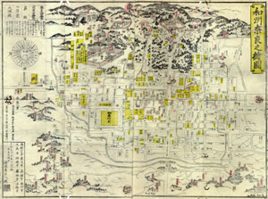
Among the three old maps, this is the only multicolor one. It is small in size (50 by 65 centimeters) and can be folded for easy carrying. It also includes tourist information such as yearly events in Nara and directions and distances to the tourist sites from the center of Nara. Therefore, it can be characterized as a tourist map.
In the upper (east) area of the map there are major tourist sites such as Todai-ji (Buddhist monastery famous for its enormous statue of Buddha) and Kasuga-Taisha (Shinto shrine). In this area, the illustrations are remarkably pictorial and distorted. For example, figures of deer are found in this area. Therefore, users of this map can enjoy the sightseeing pleasure of Nara in their homes. This map might also be brought home as a souvenir from Nara.
Ezu-ya, the publisher of this map, was the most important publisher in Nara at the time. It also published tourist guide books of Nara. People in the Edo period were provided with tourist information by such publishers.
By Hiroyoshi Yamachika, Osaka Kyoiku University