 |
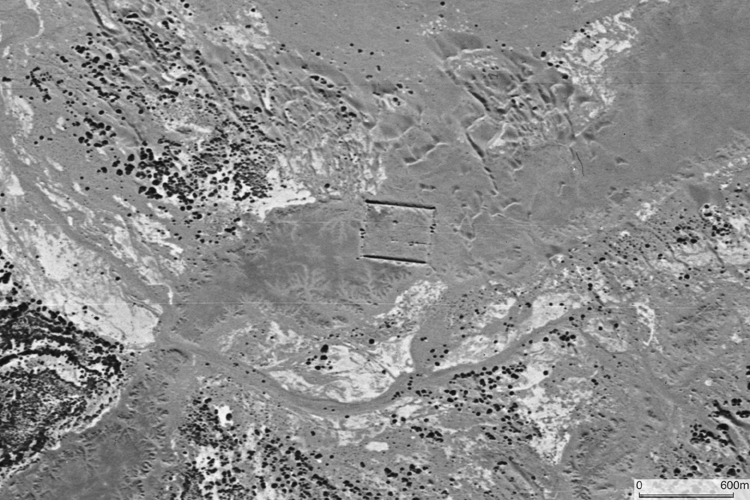
| CORONA satellite photograph over the city ruins of Kharakhoto taken on September 29, 1969. |
| ‘When you leave the city of Campichu [modern Zhangye] you ride for twelve days, and then reach a city called ETZINA, which is towards the north on the verge of the Sandy Desert; it belongs to the Province of Tangut [territory of Western Xia Kingdom]. The people are Idolaters, and possess plenty of camels and cattle, and the country produces a number of good falcons, both Sakers and Lanners.’ |
| — The Travels of Marco Polo translated by Sir Henry Yule, Chapter XLV. |
| ‘In the misty weather Khara-khoto might easily have been taken for a living town; it was only possible at quite close range to discern the defects in the mighty walls banked to the the very top with softly modelled sand-dunes. The effect is one of great beauty: the walls are tinted rose where the few sunbeams succeed in piercing the clouds, the dunes are golden brown, and these colours form an exquisite contrast to the light blue paches of sky.’ — Folke Bergman’s Report, January, 1931. |
| — Bo Sommarström (1958) Archaeological Researches in the Edsen-gol Region Inner Mongolia, Part II, p. 189. |
Walled city ruins of Kharakhoto is considered to have been founded by the Western Xia (Tangut) Kingdom and after it was taken over by the Mongol Empire, the walled enclosure was enlarged. We can observe a smaller rectangular enclosure adjacent to the northeastern corner of the major rectangle. This smaller enclosure is believed to have been of the Western Xia period. On the above satellite photograph, we can find traces of branching streams which once watered this area although it is completely desertified today. P. K. Kozlov, who explored Kharakhoto site in 1908, noted local people's legend in his report. The legend reported is as follows; the troops of the emperor of China wanted to capture the city of Kharakhoto, but they faced difficulties. In order to conquer the city, the emperor’s troop operated to change the stream of Ejina River ‘to the left’ to stop water supply. Observing the shift of the oasis on the LANDSAT image, this legend poses an interesting question in spite of difficulty in verifying the actuality.
CORONA satellite photographs are available from U. S. Geological Survey, EROS Data Center, Sioux Falls, SD, USA.