 |
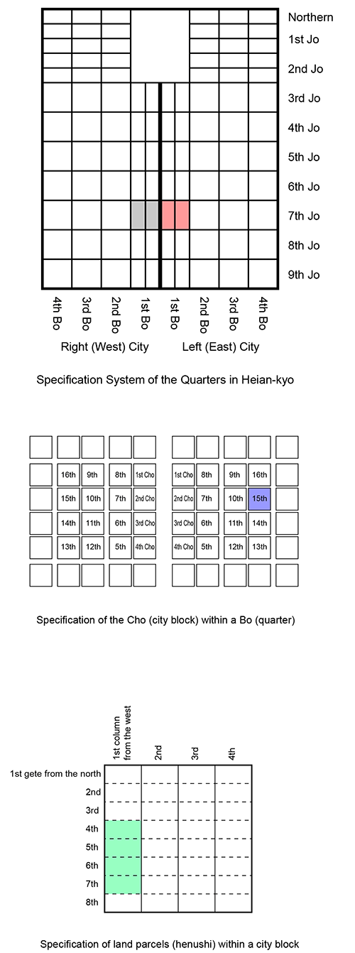
| Diagram of the system of specifying city blocks and land parcels in Heian-kyo based on the city planning |
— City Planning and Land Management System of Classical Japan —
Japan’s ancient capitals were planned and built based on the framework of a grid pattern known as the Jō-Bō System borrowed from China. Fujiwara-kyo (694-710), Nara (710-784), and Nagaoka-kyo (784-794) were built in this way. Heian-kyo (Kyoto) was also carefully planned and built on a grid pattern system. The city planning system was not only pertinent to the physical layout but also to land management. Based on grid pattern city planning, land parcels were easily and clearly specified numerically on documents.
Academic research of Japanese history is generally based on primary sources such as records (kiroku) and documents (monjo). While most of the records before the early modern times are diaries written by members of the aristocratic class in Kyoto and Nara, most of the documents are related to transactions and the cataloging of assets and estates owned by noble families and Buddhist temples. Tō-ji (also known as Kyō-ō-Gokoku-ji), a famous Buddhist temple founded in 796 in Kyoto, has accumulated a vast number of documents since the eighth century. These valuable documents are collectively called the Tō-ji Hakugō Archives (documents contained in one-hundred boxes) and were listed in the Memory of the World by UNESCO in 2015. The temple owned many estates, and the Hyakugō Archives include many documents related to the management of the estates.
Among the Hyakugō Archives, we can find a series of interesting documents concerning the exchange of a piece of land inside Kyoto. A document titled Shichijō-Ryō-no-Ge (document issued by the chief of the seventh ward) was dated the 20th day, sixth month, fourth year of the Shōryaku era (July 12, 993, Julien). It concerns a request to approve the transfer of the land from Kishi Tadakane (seller) to Ki Shigetada (buyer). The land was specified as “Area consisting of the four land parcels, namely the fourth, fifth, sixth, and seventh gate from the north, first column from the west, 15th block, first quarter of the seventh ward, Left City.” This description of the document clarifies the ancient system of land parcel specification. The method of land partitioning and specification went on as follows:
First, the capital was divided into the Left (East) City and the Right (West) City. Then the Left City was divided into ten wards (Jō), namely first to ninth from north to south, aside from the northern ward. Next, each ward was divided into four quarters (Bō: 516-meter square), first to fourth from west to east. This way of locating a quarter seems similar to the Cartesian coordinate system. Each quarter was divided into 16 (four by four) city blocks (chō: 120-meter square) and numbered from the 1st to the 16th. Finally, each city block was divided by four columns and eight gates (rows) into 32 land parcels (henushi), which are 30 meters (east-west) by 15 meters (north-south).
Accordingly, we realize that people in ancient Japan not only implemented their city planning precisely but also had the systematic idea of specifying land parcels using numbers in multiple scales without maps. Although the land partitioning and specification system described above in the Heian Period is no longer in use, people have designated locations within Kyoto by combinations of north-south streets and east-west streets crossing at right angles until today.
 |
| Diagram of the system of specifying city blocks and land parcels in Heian-kyo based on the city planning |
By Noboru Ogata, Emeritus, Kyoto University
[References]
Since March 30, 2018
![]()