Jôri System in the Nara Basin
Land Information System in Ancient and Medieval Japan
Jinson, a Buddhist priest in the 15th century,
was the chief of Daijô-in Monzeki Temple in Kôfuku-ji
(Buddhist monastery) in Nara. A monzeki was a Buddhist
temple headed by a priest from noble lineage, and Jinson was from
the Ichijô family among the Fujiwara Regental Families.
In those days, the Muromachi (Ashikaga) shogunate in Kyoto was
in decay and, in 1467, the Ônin War broke out, which caused
a disturbance in the Kansai district. He wrote a journal called
Daijô-in Jisha Zôjiki, which is a famous record
of social unrest and uprisings amidst the people of the time.
Since Daijô-in owned many estates in and around the Nara
Basin, Jinson also recorded every sort of minute affair concerning
the management of the temple.
On the 28th day, 5th month, and 11th year of the Bunmei era (June
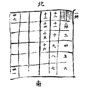
19, 1479 by the Julian calendar), Jinson wrote in his journal that
a priest of another temple in Kôfuku-ji came to show him
"an old chart of rice fields." The chart, a copy of
which he drew in his journal (below), illustrated the framework
of how the land parcels were laid out and numbered.
 |
 |
|
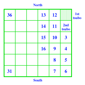
An illustration from Daijô-in Jisha
Zôjiki and its interpretation (right) |
He also noted the conventions of
layout and numbering of land parcels as follows.
- The size of one ri (village) was 6 chô
square while one tsubo (land parcel) was 1 chô
(109 meters) square.
- The lateral arrays of ri were called jô,
which were numbered from north to south.
- In one jô, ri were numbered from Shimotsu-Michi
ether to the west or to the east.
- Shimotsu-Michi, or the Lower Road, divided the eastern and
the western counties of the Yamato Province. (It was a north-south
road built as the central axis of the Nara Basin preceding the
construction of the Capital Nara in 710 AD. The main street of
the capital, Suzaku-Ôji, was the extension of Shimotsu-Michi.)
- In one ri, tsubo were numbered from the northwest
corner to the northeast corner in the eastern counties, and from
the northeast corner in the western counties.
The above illustration and description gives the synopsis of
the so-called jôri system i.e. the land partitioning
and indication system in ancient and medieval Japan.
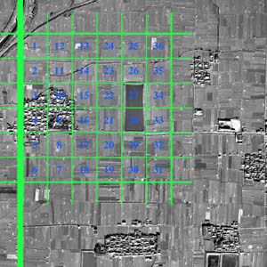
An aerial photo over Hieda village in Yamato-Kôriyama City
overlaid by the jôri plan.
In the aerial
view over the Nara Basin, the square grid-pattern of rice fields based
on the jôri system is one of the most remarkable
features of the region. According to recent studies, the jôri
system, as well as the jôbô
system, was derived from the ancient ritsuryô
(legal) system and had been implemented since the 8th century.
Under the ritsuryô system, the entire land was owned
by the state and granted to the people, but such a system soon
fell dysfunctional. Nevertheless the jôri system
continued to be used in management of private estates throughout
medieval times. Today the traces of this system can be found in
many districts of Japan but most typically in the Nara Basin
as shown in the above aerial photo taken in 1961. Inferencing the numbers originally
given to land parcels from the place names,
the jôri plan in the Nara Basin is almost completely
restored by scholars.
By Noboru Ogata, Emeritus, Kyoto University
References
- Kinda, Akihiro (1986) The Jôri Plan in Ancient and
Medieval Japan, Geographical Review of Japan, Vol. 59
(Ser. B), No. 1, pp.1-20.
- Archaeological Institute of Kashihara (1980) Yamato-no-Kuni
Jôri Fukugen-Zu.
Last updated: 23/Jan/2004